S1 for science Ocean study

an ESA SEOM project

A series of extreme hurricanes monitoring benefited from SEOM improvements

Irma was the strongest hurricane ever measured in the North Atlantic (on a par with the strongest North Pacific typhoons). The damages it caused for populations and infrastructures are still under assessment, but losses and costs will definitely be huge.
A number of satellites have been mobilized to forecast and assess the phenomena and the following hurricanes, and to help the emergency rescue teams.
Sentinel-1 A & B, which acquisitions were not at first optimized for such phenomena, were specifically programmed to observe the hurricane Irma as it moved. Others satellites were also used to monitor the exceptional series of hurricanes of September 2017, and also to assess the damages afterwards.

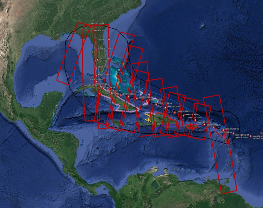
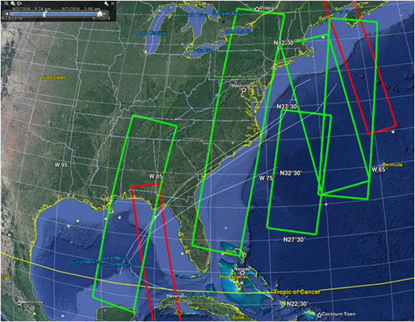
Sentinel-1 acquisitions programmed for Hurricane Irma, following the forecasted path of the cyclone (6 to 10 September 2017). (Credits Ifremer-LOPS )

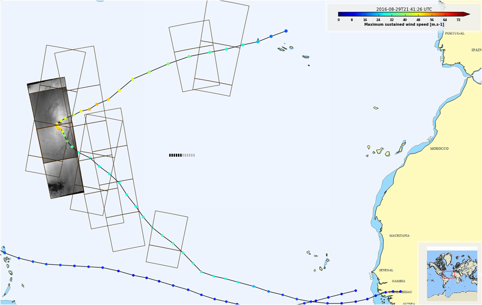
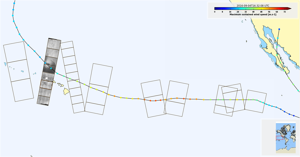
The SEOM S1 for Ocean study project has in particular the objective of improving wind and wave retrieval from SAR (Sentinel-1) imagery, especially in extreme conditions where SAR-derived wind measurements are usually largely under-estimated. Taking advantage of the cross-polarization channel, a dedicated wind retrieval algorithm was developed to avoid co-polarized channel limitations in extreme conditions. This was allowed by the numerous Sentinel-1 acquisitions over hurricanes performed in summer 2016 in collaboration with Sentinel-1 ground segment. Observing Irma constitutes a kind of test for this project, since such extreme events are out of the normal range of expected values, and thus are always a challenge for observing systems.

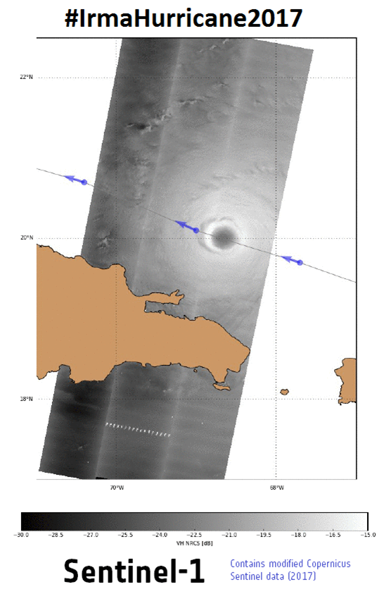
Sentinel-1 image on Sept. 7th crossing the eye of hurricane Irma (Credits Ifremer-LOPS )

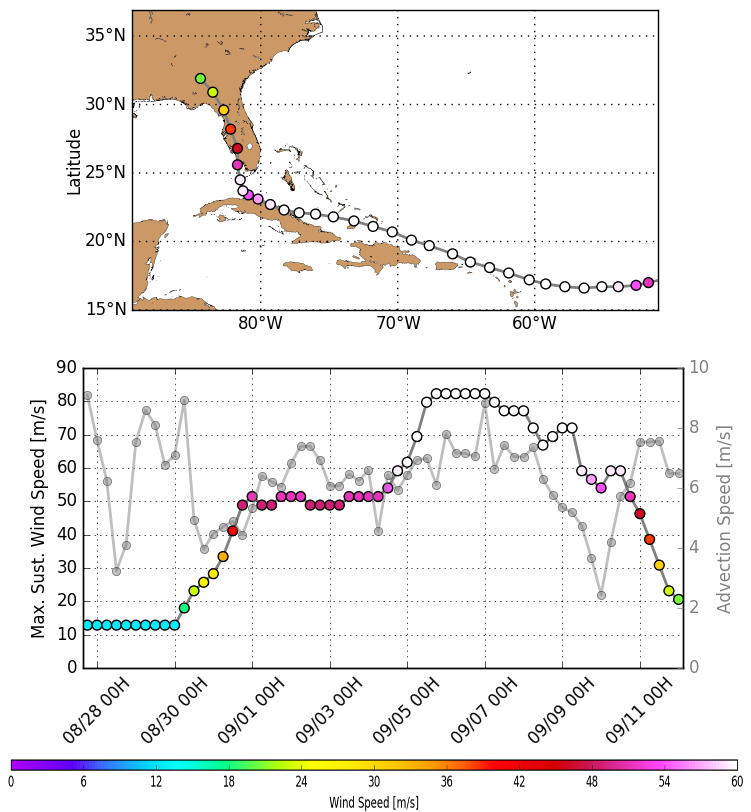
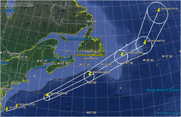
Hurricane Irma path (with wind speed color-coded), Wind evolution along time as analyzed by NHC (best-track data) (Credits Ifremer-LOPS )


Acquisition over Irma on September 7th, 2017 is the first SAR image ever capturing a hurricane for such a high wind speeds (as reported by Hurricanes experts). Wind field algorithms developed in the framework of the ESA SEOM program report wind speed up to 80-85 m/s (about 300 km/h). The following hurricanes (Jose and Maria) were also monitored using S1.

Jose also benefited from a S-1 acquisition over the eye (Credits Ifremer-LOPS )

The provided polarization channels gave very interesting results, with the cross-polarisation (VH) much more sensitive to extreme sea states than the parallel polarization one (VV). This opens perspectives for measuring wind speeds over extreme with new algorithms for Sentinel-1 and the next MeTop SG scatterometer (VH capabilities).

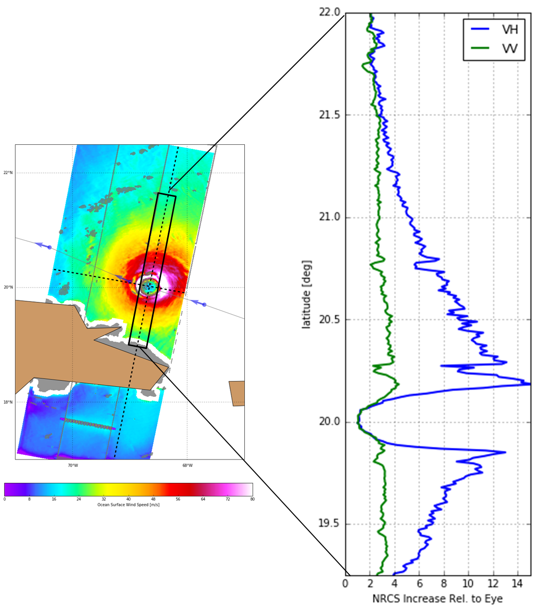
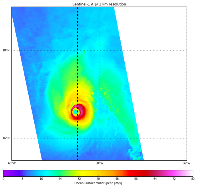
Wind speed for Irma (Sept.7th acquisition), and the sensitivity of the two polarizastions. The sensitivity of SAR backscatter to ocean surface wind speed in VH is much stronger that in VV. (Credits Ifremer-LOPS )

The algorithms developed in the framework of ESA SEOM program can thus be used to provide geophysical parameters over hurricanes, even if some improvements can still be brought to them, made possible in particular thanks to other observations (in that case, SMOS was collocated with S1 over Irma and Jose). Specific acquisitions are to be thought of in that frame.

SHOC campaign first results

ESA launched the SHOC campaign during the peak of the 2016 cyclonic season to try and test a rapid-response programming of the Sentinel-1 missions, compared with other measurements. The new capabilities of the onboard SAR sensors will enable to improve storm knowledge and forecast.

Hurricanes are one of the most devastating natural phenomena. If storm tracks quality has significantly improved recently, this is not the case for storm intensity – especially at high resolution. To date, Synthetic Aperture Radar (SAR) is certainly the only sensor able to provide a hundreds of kilometer-wide description of a hurricane with the highest resolution to measure these parameters when the storm is very severe with extreme winds and very small radius of maximum wind speed.

All S1 acquired acquisitions over Hurricane Hermine (green for Extended Wide mode, red for Interferometric Wide mode) with successive forecast trajectories.

All S1 acquired acquisitions over Hurricane Hermine (green for Extended Wide mode, red for Interferometric Wide mode) with successive forecast trajectories.

In that frame, the European Space Agency and the Sentinel-1 Ocean study consortium launched an observation campaign, SHOC (standing for Satellite Hurricane Observation Campaign), planned during the 2016 hurricane season. Acquisitions were performed over Northern Atlantic and Northern Pacific Basins in August and September 2016 to target both typhoons and hurricanes during the peak of the cyclonic season.
The aim is to collect satellite observations over such extreme events, co-located with other data sources, taking in particular benefit from Sentinel-1A measurements, complementing low resolution (about 40 km) radiometer winds. Observing ocean surface night and day and through clouds at high resolution (50 m) and with wide coverage (400 km swath), Sentinel-1 is expected to provide a high resolution wind speed synoptic view of hurricanes.
The main challenges for SHOC are to improve our understanding of microwave radar measurements over extreme events and provide key parameters for tropical cyclones characterization, and to do so based on Sentinel-1 late programming scenario. This campaign was organized within the framework of the SEOM ESA program as part of the Sentinel-1 Ocean study including CLS, IFREMER, NORUT and OCEANDATALAB, and supported by a worldwide user community. The SHOC consortium benefited from ESA Sentinel-1 mission planning team who made possible programming late acquisitions over hurricane tracks. These tracks were kindly provided by NOAA (National Oceanic and Atmospheric Administration) over the Atlantic, Central and Eastern Pacific Ocean while hurricane forecast tracks over the Western Pacific Ocean were obtained through the NMC (National Meteorological Center of the China Meteorological Administration).

Sentinel-1A acquisition over Gaston along its path. Color-coded tracks indicate maximum sustained wind speeds measured along hurricane paths

Sentinel-1A acquisition over Gaston along its path. Color-coded tracks indicate maximum sustained wind speeds measured along hurricane paths

Among the 70 Sentinel-1 passes scheduled by the mission planning team over the hurricane forecast tracks, 22 images capturing the hurricane/typhoon eye were gathered. Tropical cyclones were captured at different development stages. Some tropical cyclones like Lester and Gaston have been imaged by Sentinel-1 up to ten times each, including at very intense stages. The most intense winds expected to be measured by Sentinel-1 were captured over Typhoon Lionrock and Hurricane Lester, respectively in Category-3 and 4 on the Saffir-Simpson hurricane wind scale at acquisition time, corresponding to maximum sustained winds between 50 and 58 m/s for Lionrock, 59 and 69 m/s for Lester.

Sentinel-1A acquisition over Lester along its path. Color-coded tracks indicate maximum sustained wind speeds measured along hurricane path.

Sentinel-1A acquisition over Lester along its path. Color-coded tracks indicate maximum sustained wind speeds measured along hurricane path.

Sentinel-1 images over open ocean areas were acquired in Extended Wide TOPS mode (400 km-wide swath and 50 m resolution) and in Interferometric Wide TOPS mode over coastal areas (250 km-wide swath and 20 m resolution), all of them in dual polarizations.


The availability of the cross-polarization can greatly complement the co-polarized channel due to its higher sensitivity under extreme wind conditions, which will improve Sentinel-1 capability to describe such conditions by better resolving extreme winds for instance.
Reference data for high wind speed have been provided by other remote sensing sensors such as radiometers (SMOS, AMR2 or SMAP), analysis from best tracks and dedicated measurements from the NHC, National Hurricane Center (USA). Indeed, during the hurricane season, NHC organizes air flights with both radiometers and drop-sounders on over the Gulf of Mexico, West North Atlantic or East Pacific regions.

SHOC initiative has shown the possibility to trigger Sentinel-1 acquisitions within less than 24 hours over monitored hurricanes. The archive accumulated over summer 2016 has already given the possibility to develop first prototype dual-polarized winds showing a much better retrieval of the overall wind field and extremes. The new dual-polarization capability of Sentinel-1 should directly benefit to Copernicus end users in delivering higher quality ocean wind measurements. This demonstration sets the ground for future Copernicus services of operational extreme wind monitoring, providing a unique description of storms at high resolution before they reach populated areas. It also provides a rich dataset to better understand and forecast these phenomena.
SHOC will also help to prepare the next European Earth Observation missions since the new generation scatterometer, MetOp-SG SCA, will also perform cross-polarization observations. In this matter, the availability of a wide dataset of cross-polarized C-band measurements from Sentinel-1 constelation and derived algorithm will help prepare the exploitation of this future European satellite.

More information on the SHOC hurricane observations with Sentinel-1 will be given in the upcoming weeks.
http://eoda.cls.fr
http://ovl.oceandatalab.com/

Data Access

Sentinel-1 products acquired within SHOC initiative are accessible via the scihub (www.scihub.esa.int). Also, SHOC archive can be accessed via ftp (please email to rhusson@cls.fr).

SHOC campaign is waiting for its first hurricane

    • What: Observe and calibrate extreme surface winds in hurricanes with Sentinel-1
    • Where: Gulf of Mexico and Western Atlantic Ocean
    • When: August-September 2016, during peak hurricane season
    • Participants: ESA/ESRIN, ESA/ESTEC, EUMETSAT, CSIC, NOAA, NASA

SHOC, standing for Satellite Hurricane Observation Campaign, is a campaign planned during the 2016 hurricane peak season (August and September) which aims at collecting observations over hurricanes in order to provide a synoptic view of hurricane development and evolution. Sentinel-1 data is the key resource of the SHOC experiment.

The main goal of this campaign is to acquire a maximum of Sentinel-1 products over hurricane eyes or edges, co-located with other data sources. One important constrain is to take benefit of the efforts done at NHC, the National Hurricane Center (USA), to collect measurements during air flights with both radiometers and drop-sounders. This leads us to focus the campaign on the Gulf of Mexico (GoM), and West North Atlantic, a place known for its strong tropical cyclone activity, particularly peaking in August/September.

During this campaign, SHOC consortium will benefit from additional support from NOAA in distributing hurricane forecast track and from ESA S1 mission planning in enabling late programming acquisition over hurricane tracks.

News and results on SHOC will be distributed on the website as the campaign evolves.

Example of hurricane forecast cone based on NOAA provided information and used by Sentinel-1 Mission Planning team

Example of hurricane forecast cone based on NOAA provided information and used by Sentinel-1 Mission Planning team